The Island of Niue
August 1, 2003
After three months of French Polynesia we were ready to move on to the west. On July 18th we had 550 miles ahead of us to journey to the Southern Cook Islands. Lying 4,500 miles south of Hawaii, the Cook Islands are comprised of 15 islands of only 240 square kilometers in an ocean area of 1.83 million square kilometers. That means a lot of water in between!
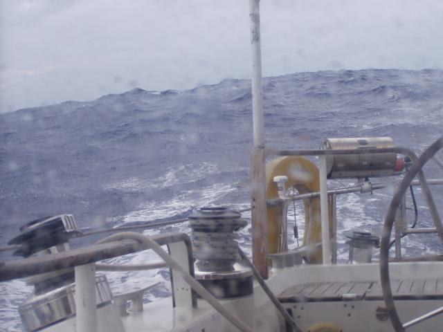
Our sail to Rarotonga in the southern group of islands was fairly quick as we had some heavy winds and some big following seas. (See photo) As we approached landfall, the winds had increased and the forecast of a counter-clockwise rotation of the winds from NE to N to NW over the next few days had us quite concerned about our safety in the harbor of Rarotonga. It is a large island but has no natural harbors. For this reason they have cut out a section of coral on the north coast and the boats are required to moor with the back ends in towards land and the bow of the boat at anchor. All the boats end up side by side and (due to the northern entry of the harbor) are facing the harbor entry. When the winds come around to the north, the boats are directly exposed to the heavy seas which push right on into the harbor. When northern weather is expected, it is common for the harbormaster to turn all the boats back to sea.
On our arrival the winds were out of the NE and blowing 20-25 knots. The harbormaster was not available to give us advice about what to expect so we motored on into the harbor. It did not take long for both of us to have the same gut reaction to the situation…too small, too crowded and too exposed to the sea. We turned right around and motored out of the harbor and set sail for the next destination 585 miles away. We were very disappointed about missing the time in the Cook’s but the safety of the boat always must be our top priority. The next stop was to be the island of Niue, an independent nation with a close affiliation with New Zealand. This island is affectionately called “The Rock” by many. Two tiers form the island with the lowest tier being about 20 meters above the sea and the inland layer another 40 meters above that. Faulting during the island’s uplifting created the chasms and crevices that are Niue’s greatest attraction. The sea often finds its way past the bordering fringing reef and crashes directly into the cliffs with the breakers sending enormous spray booming into the air. It will not be a surprise to learn that there are no natural anchorages in Niue either. This does not deter the Niuean people from encouraging the visits of cruising boats, as you will learn below.
The sad thing about Niue has been the loss of its people. At the time of independence in 1974 there were 4,000 people here, in 1996 – 2,300 and today only 1700. Because of their association with New Zealand the people of the island are free to travel to and settle there. There are 14,400 people from Niue who have made this transition. You can imagine that the island is rather like one big ghost town where whole villages have only one or two houses still occupied. We found that the few people who remain in Niue, however, are some of the most friendly that we have ever met anywhere. And they speak English! It has been so strange to see the signs in English and to hear our native language spoken all around us.
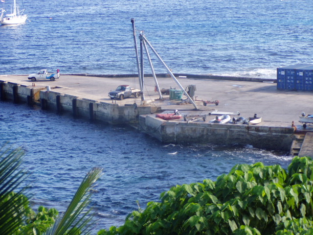
We are currently on a mooring which is a huge concrete block 90’ below the surface of the water. You can see the bottom as well! There are no rivers exiting the island and this fact explains the clarity of the water – 75’-100’. Because of the ocean swells from the south the ride on the mooring is a little uncomfortable as it causes a lot of rolling around. The swell also presented a different challenge to the locals…how to get the small boats onto shore safely. There is a huge concrete wharf with a small crane at the top. (See photo) When we come in our dinghy, we must attach the big hook from the crane to the harness on our dinghy and then use the crane to lift it out of the water for storage on the wharf. It can be quite a challenge to do all this in the ocean swell.
We were lucky to rent a car with some German friends of ours to tour the island. And what a treat that was! They have done a marvelous job here developing “sea tracks” down to the edge of the water. Sometimes there are tidal pools in which one can swim and snorkel. Sometimes the landing is just too wild to offer swimming, but every landing has marvelous views and interesting surroundings. One of the sea tracks involved a 15 minute walk through the woods initially. We were amazed to find forests with huge banyan trees – all said to be primary growth. At the end of the forest the track starts down through the jagged coral with concrete pathways, steps and guardrails to hold onto. Part way down the path leads to a wide chasm with coconut trees growing in a sandy bottom. We climbed down a big ladder to get to the sand and the surrounding pinnacles which were 50’ above us. (See photo) From there we could hear the pounding of the surf very close at hand…a very unique experience.
This is our third day here and we have not quite decided how long to stay. Jane has a reservation to go diving with a local dive outfit tomorrow morning. We are carefully watching the forecasted weather as it will take us two days to cover the distance to Tonga – 250 miles to the west. We would rather do that trip with good winds rather than needing to motor the whole way. The South Pacific presents problems in forecasting the weather. It seems that the weather men are willing to guess what will happen the next two days – further out seems to present a big dilemma. Will the lows to the south of us move to the SE? Will the current high pressure system remain stationary? Etc Etc!
We do have some photos to send to you from Niue and are hoping that the single internet here will be able to make the connection to our hotmail account. We look forward to hearing from all of you on our ham radio e mail system which is: **
Till later, Jane and Sander aboard Satori
 |  |  |